On May 22, 2025, Winshear announced it entered into an agreement whereby the Company can earn a 100% interest in the 360km2 Thunder Bay Gold Project located immediately Northeast of Thunder Bay, ON, Canada. The company is currently conducting a regional scale exploration program on the project.
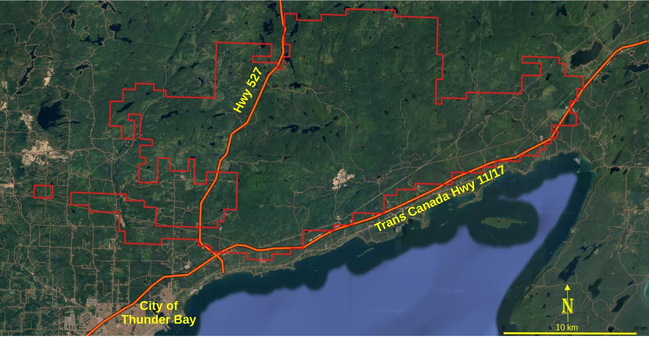
Map 1 – showing the outline of the Thunder Bay Gold Project
Overview of the Thunder Bay Gold Project:
- Eastern extension of the Archaean age Shebandowan greenstone belt;
- Very little historic exploration conducted in the TBGP area;
- Potential for orogenic gold, volcanogenic massive sulphides, and nickel–copper–cobalt sulphide deposits;
- Evidence of geological structural setting similar to other gold-endowed Abitibi greenstone belts in Ontario (Map 2).
- Historic reports indicate the presence of high-grade gold mineralisation (>1 oz/T Au) at the Gold Hill and Eldorado prospects (described below).
Map 2 is a total field magnetic plot (OGS 1991 data) showing regional structural architecture including the Thunder Bay Fault, Kingfisher Fault and associated bridging structures. Magnetic low anomalies coincide with some of the regional structures, interpreted as possible magnetite destruction from extensive hydrothermal alteration and considered indicative of a large scale orogenic gold system.
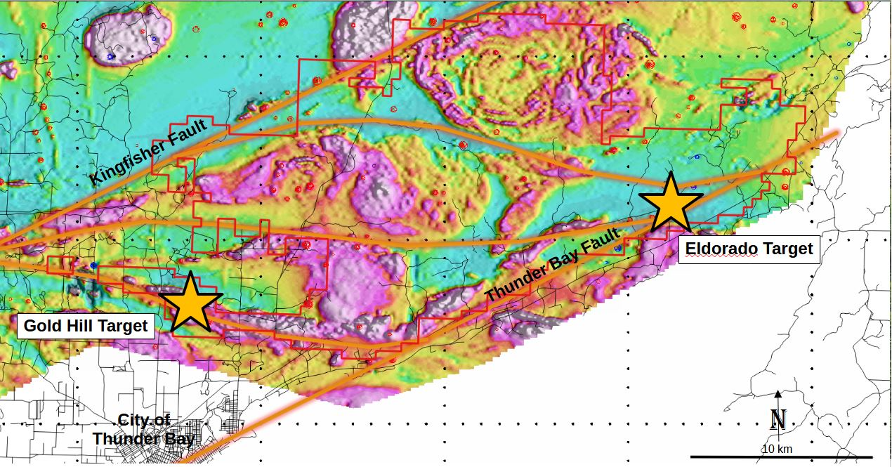
Map 2 – showing the magnetic character and structural make-up of the Thunder Bay Gold Project
The Gold Hill Target
The Gold Hill Target is located at the western end of the project area. A Noranda report by Thomson (1989) describes numerous high grade gold veins occurring at the historic Thunderhead, Lakehead and Gorham Gold Mines located immediately to the north of the Thunder Bay Gold Project. These include values of:
- 21.6 g/T Au across 0.76m for a length of 59.5m
- 24.5 g/T Au across 0.55m for a length of 76.3m
- 20.6 g/T Au across 0.6m for a length of 105m
- 11.0 g/T Au across 1.1m for a length of 85.4m
- 40 ton bulk sample assayed 20.6 g/T Au (1980)
Thomson concludes: ‘A structural zone consisting of multiple shears with numerous gold bearing quartz veins trends through the Gorham properties… gold mineralization occurs along a strike length of 8 km within this structural zone which is at least 500m in width. Previous work has been focused only upon the limits of vein exposures originally uncovered in the 1930s and 40s and has not attempted detailed prospecting or stripping to locate economic widths along strike or to identify additional veins structures which might have economic potential.1
2025 Work Program
In September 2025 Winshear publisched new geochemical results from reconnaissance mapping, prospecting and basal till geochemical sampling at the Thunder Bay Gold Project.
Numerous areas for follow up have been identified, the most prominent of which is the discovery of a six kilometre-long series of anomalous gold-in-till samples named ‘Inflection’, which is located in the central / southern part of the project area (see maps below).
Targets for follow up:
Inflection
The Inflection target represents a newly discovered gold anomaly with up to 44ppb Au in till samples. The area covers the intersection of several east-southeast and west-southwest trending structures and contains a complex mix of felsic to intermediate volcanics, clastic metasediments, and komatiitic ultramafic rocks. Historic mapping in the area has noted abundant stockwork quartz veining in felsic volcanic rocks. This area has not seen any significant historic exploration, and is a priority target for the Company.
El Dorado
Located in the eastern section of the project area, rock and till geochemistry returned modest gold, silver and copper values that warrant further follow up. Historic sampling by Ontario Geological Survey has returned up to 36.3 G/t Au in arsenopyrite bearing quartz veins in this area (Ontario Mineral Deposit database MDI152A10SW00032).
Central and Northern Areas
Anomalous gold in till samples were found in the central and northern parts of the project area, where sampling density is very low. These targets are located close to strong structural lineaments as seen in the magnetic response. Government mapping in these areas is sparse. Additional sampling is being planned in a follow-up program to flush-out the extent and source of these anomalies.
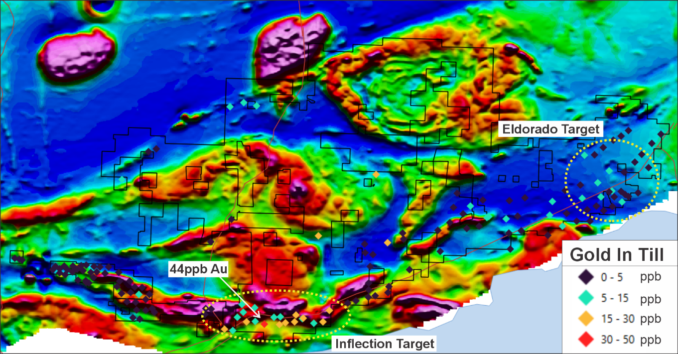
The Inflection Target – Showing an anomalous trend of till samples extending over 6.5 kilometres, ranging from 10 ppb to 44 ppb gold
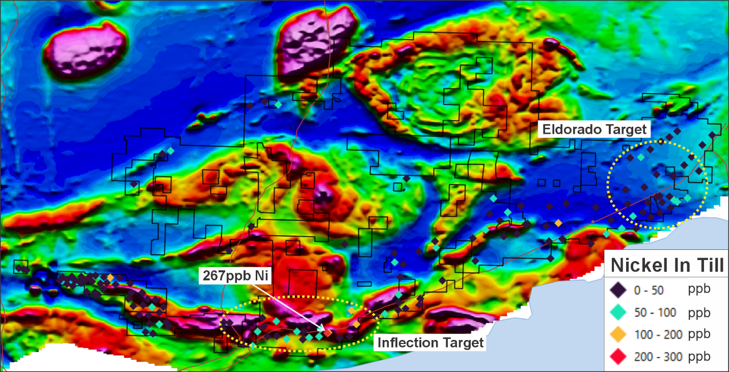
Sample 1298568 shows a distinct ultramafic signature, with 267ppm Ni, 933ppm Cr and 3.86% Mg and potentially Cu-Ni-PGE signature with 186ppm Cu, 11ppb Au and 51ppm Co
Notes
1. link